Improving trails and trail access in and near Nevada County (Northern California).
Monday, July 23, 2012
Wetherall Trail Impressions
Recently, I had the privilege of hiking the Orene Wetherall Trail. Thanks to the Bear Yuba Land Trust, this trail is now a complete loop which begins off the Cascade Canal on Banner Mountain. The trail meanders down into the beautiful Woodpecker Preserve, which is protected open space managed by the Land Trust.
As someone who has volunteered to build and maintain many local trails, I am struck with the challenge successfully met by constructing this trail. Like many areas of Banner Mountain, the terrain is highly irregular and quite steep. As with the Hirschman’s Trail, historical mining activity can make planning trails on local lands quite complex. The resulting Wetherall trail route is thus very twisty and narrow as it winds its way through the preserve. The Land Trust trails program did a great job creating a trail that is fun to hike and bike while not too steep for either activities. Plus, trail users get to experience first hand the varied wildlife and plants featured in the preserve.
The Cascade Canal is a very popular destinations for trail users who seek out its beautiful vistas, forest shade and pretty canal water. The Land Trust has expanded this wonderful destination for the community by providing connectivity to the Wetheall loop, which unlike the canal trail offers a bit of climbing and descending. The Land Trust plans even more trails in this general area, so stay tuned for details!
Monday, July 16, 2012
Looking Down from the Black Buttes
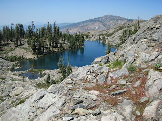
Grouse Ridge continues to have a special place in my heart. Just up the road from Grass Valley, it features some of the most beautiful vistas, lakes and granite landscapes anywhere in the Northern Sierra Nevada.
My love affair with Grouse began on my mountain bike seventeen years ago as I tackled its relentless rocky trails. But like all exceptional networks, it is often best enjoyed on foot where you can take in its beauty at a slower pace. With this in mind, I set off yesterday with my border collie on a trek between Grouse Ridge itself and the Black Buttes.
The hike itself is a 7.5 mile journey out and back. I decided to scale the broken rock of the stunning buttes above Glacier Lake to take in the exceptional views atop this 8K foot set of peaks. It is a short, somewhat strenuous ascent, but well worth the investment once you absorb the 360 degree views from the Tahoe Basin to the Sacramento Valley and beyond.
I noticed that the Forest Service and Eagle Scouts teamed up to place desperately needed signage at trail junctions in the area. BONC and IMBA plan a weekend of riding and trail maintenance starting on September 14th. All this is wonderful, as Grouse never quite gets the volunteer attention it deserves. All things considered, I think it is the far and away the best trail network in our area.
Subscribe to:
Posts (Atom)