Wednesday, October 31, 2007

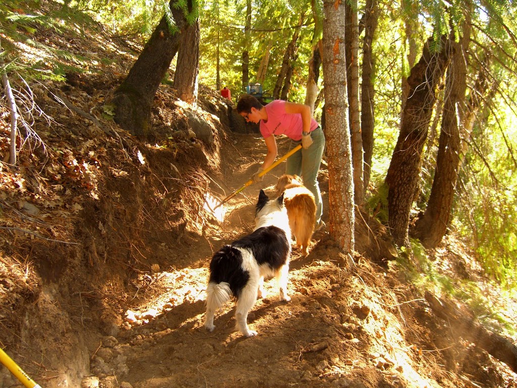
Narrow Gauge/Tressel Trail Work Day - Sunday, 11/4

From the GCTC: Due to forecasted inclement weather, this work day has been rescheduled to Sunday, November 4. Questions? Please contact Melissa at 530.268.1378

Volunteers needed to complete this important project! This is the last workday of the year and your last chance to come out and make a difference on our trails.

When? Sunday, Saturday, October 20, 2007
Time? Meet at Skillman Campground (13 miles east of Nevada City off Highway 20) at 9 a.m. We will carpool from Skillman to the work site and be finished by 1 p.m.

Why? We will be completing the re-route of the Narrow Gauge/Tressel Trail. Please bring loppers, rakes and shovels. Bring drinking water and a lunch.

Per Forest Service requirements, long sleeve shirts and pants and close-toed shoes are required; please wear gloves. Hope to see you there!
Recap: Empire Mine Workshop

Saturday's Empire Mine trail workshop was very positive and super exciting; generally speaking, State Parks has some great plans for new trail and restored trails in the Osborne Hill area of the park.

Starting as early as March, State Parks will begin construction on new sections of trails. Pending input from the community, they will generally use the same names, but the trails in this area will be very different. The net mileage of trails here will increase a bit, but most exciting is that much of the new trails will be comprised of singletrack.

State Parks plans to re-work the super fun user-built trail that follows the fence line along Osborne Hill Road to be mountain bike-specific. This means it will be optimized for mountain bikers, with rock armoring and fun up-and-down sections.

The existing Powerline, Osborn Hill and other trails will be complete removed and replaced with singletrack. There will be a net loss of fireroads in this whole area of the park, which will be replaced by singletrack on a 48" bench cut, which of course will narrow to an ideal width within a few years

The two parts of the proposal that I am not happy with are the sections of hiker-only trails and the proposal to remove some user built trails. The hiker only built trails idea was widely denounced by attendees (equestrians, cyclists and even some hikers) and I believe that State Parks got the message that this is lousy idea that would deprive many of us of trail access. As for the user built trails, I believe that some of these are sustainable trails that should be adopted in the system as-is or with some modifications.

These plans are in draft form and State Parks want your input ASAP. Note that this project is fully funded. This means that whatever final plans are agreed upon will move forward very soon. This is why it is important to comment on this projects within the week.

Tuesday, October 16, 2007

Nevada City Trailwork, 11/3

Please join the Miners high school mountain bike team as we revive the trails around the old airport in Nevada City. This is your chance to add to local riding so close to town.

Meet at 9AM at the old airport parking lot. To get there, head up Airport Road (see map link below). If bad weather occurs, please call 530-274-DIRT after 7:00AM on 11/3 to determine if the event will be rescheduled. Map.
Forest City Trailwork

Sunday's planned trailwork at Bullard's was moved over to Forest City upon the suggestion of Joe Chavez of the USFS. There we worked on an entirely new section of the Sandusky Trail that has been punched in by Zachi Anderson. This new section is *great* and represents of lot of talented work by Zachi. The new section of Sandusky will be sweet to ride once winter works its magic on it. There are also some freeridish features on it that I look forward to hitting.

Today's effort involved finishing work on the trail bed by BONC volunteers, as Zachi worked the excavator. I believe Bob, Jimmy and Christine joined Joe Chavez on some brushing work as well. Thanks to everyone who helped out.

Pictures:
http://picasaweb.google.com/velojohng/SanduskyTrailwork

Thursday, October 11, 2007

Bullard's Bar Trail Day

Please join BONC as we help improve this exceptional trail system with the Forest Service. We'll have some swag for participants, food, drink and quality beer. I am sure some of us will ride afterwards.

Meet @ 9AM (note the time) on Sunday, 10/14 at the Dark Day boat launch (map). If bad weather occurs, please call 530-274-DIRT after 7:00AM on 10/14 to determine if the event will be rescheduled.

Thursday, October 04, 2007

Empire Mine Workshop - Saturday, 10/27

Did you know that State Parks is considering re-routing and closing some existing trails in Empire Mine and building brand new ones? The park wants to hear from you about all this. Please plan on attending this super important workshop (see below). You'll be able to speak firsthand with the folks who will create new trails at the Mine:

++++++++++++++++++++++++++++++

FOR IMMEDIATE RELEASE:
Contact: Sheryl Watson, Information Officer
(916) 654-7538
October 4, 2007

Ron Munson, Sector Superintendent
(530) 273-3884

Empire Mine State Historic Park Works to Improve and Reopen Trails
Public Invited to Workshop and Hike Through Osborn Hill

WHO: California State Parks' Superintendent Ron Munson and Trails Manager Karl Knapp.

WHAT: California State Parks invites trail users to review and discuss proposed realignments and improvements to trails in the Osborn Hill area of Empire Mine State Historic Park.

WHEN: Saturday, October 27 in the Docent Building. Come to the main visitor parking lot and into the mine yard. The Docent Building backs up to the parking lot. Open House: 9 a.m. - 10 a.m. Maps and information will be available for viewing. Workshop: 10 a.m. - 12 p.m. Presentation and Q & A.
Hike: 2 p.m. - 5 p.m. Hike participants meet at the Penn Gate parking lot at 2 p.m. Participants
must arrive with good walking or hiking shoes, a water bottle and appropriate protection from the weather. Rain will cancel the hike.

WHY: Portions of the Osborn Hill trail network were closed in January based on environmental
sampling data showing elevated levels of arsenic and lead. These metals are naturally
occurring, often in areas where gold is found, and may have been brought to the surface
during historic gold mining.

California State Parks and Newmont USA Ltd. are working to address the environmental
issues. California State Park is examining a plan to re-open closed areas to the public while
remaining protective of public health. Proposed new trail routes are being tested for metal
concentrations. Unlike most existing trails in the park that are former mining roads, the new
trails will be carefully designed and graded so as to resist erosion, allow better water
drainage and withstand heavier recreational use.

Trail users are encouraged to provide their input on trail improvements in the Osborn Hill area
during this planning stage. For more information, please contact the Visitor Center at (530) 273-8522.

Thursday, September 27, 2007

Narrow Gauge/Tressel Trail Work Day

From the Gold Country Trails Council: Volunteers needed to complete this important project!

Gold Country Trails Council - Saturday, October 20, 2007 Meet at Skillman Campground (13 miles east of Nevada City off Highway 20) at 9 a.m. We will carpool from Skillman to the work site and be finished by 1 p.m.

We will be completing the re-route of the Narrow Gauge/Tressel Trail. Please bring loppers, rakes and shovels. Bring drinking water and a lunch.

Per Forest Service requirements, long sleeve shirts and pant and close-toed shoes are required; please wear gloves. Hope to see you there!
BONC Website Wins Award

The BONC website won an award from American Trails for its Trail Guide page. The award was in the category of "TRAIL TOUR or virtual visit". Learn more.

According to American Trails: "We looked for sites that really make trails come alive, and provide effective information delivery, support volunteers, and engage the public. In short, we want to showcase ways that advocates and agencies are making a difference for trails."

The BONC Trail Guide page "uses Google Maps and Earth to depict trails in the foothills of the Sierra Nevada Mountains".

Monday, September 24, 2007

Lots of Trail Days Coming Up

Want to help make local trails second-to-none? Consider participating in these events:

Bullard's Bar, 10/14 - Please join us as we help improve this exceptional trail system with the Forest Service. We'll have some swag for participants, food, drink and quality beer. I am sure some of us will ride afterwards. Meet @ 9AM (note the time) on Sunday, 10/14 at the Dark Day boat launch. If bad weather occurs, please call 530-274-DIRT after 7:00AM on 10/14 to determine if the event will be rescheduled. Map of the Dark Day boat launch.

Old Airport, 11/3 - Please join the Miners high school mountain bike team as we revive the trails around the old airport in Nevada City. This is your chance to add to local riding so close to town. Meet at 9AM at the old airport parking lot. To get there, head up Airport Road (see map link below). If bad weather occurs, please call 530-274-DIRT after 7:00AM on 11/3 to determine if the event will be rescheduled. Map.

Round Mountain - The BLM has asked for approximately three volunteers to help install no-moto signs on trailheads at Round Mountain in October. This should be a short time commitment. Please respond to me if you are interested.

Monday, August 13, 2007

New 14 Mile Trail in Auburn?

Here is how you can make it happen:

Please take a minute to review the following information from Placer County Parks Department! It's about plans for a new trail from the Confluence. Here is how you can help:

Writing a quick letter to Mr. Andy Fisher at the address below to express support for the trail; and/or

Attending the public meeting in Auburn. Say you hope the trail will be a width much like the Connector, which was built with a SWECO and has developed a nice, narrow line. Mention that a new trail will disperse the heavy use on existing trails to improve the trail experience of everyone. Say you ride FDLT and other Confluence area trails, and have done volunteer trailwork with FATRAC, and would appreciate riding and volunteering on a new trail.

Thanks for showing your support for a new trail. If you have any questions, let me know.

Cathy Haagen-Smit
FATRAC Secretary

********************

North Fork American River Trail Project DEIR

A Draft Environmental Impact Report (DEIR) for the North Fork American River Trail project has been completed and is available for review and public comment.

The proposed natural surface trail would begin at the confluence of the North and Middle Forks of the American River and end at the Ponderosa Bridge, approximately 14.2 miles upstream. It could be used by hikers, equestrians and mountain bikers. Bridges and stream fords, staging areas, a restroom facility, signage and informational kiosks are also part of the proposed project.

The Placer County Facility Services Department is soliciting the views of interested persons, agencies and organizations regarding the project. Copies of the DEIR are available for review at the Auburn Library, 350 Nevada Street, or at the Placer County Facility Services office at 2855
2nd Street in the County Government Center, also in Auburn. It may also be viewed online or downloaded at www.placer.ca.gov .

A public meeting is planned for Thursday, August 23, at 6:30 p.m. to share information and receive comments. The meeting will be held in the Planning Commission Hearing Room in the Community Development Resource Center, located at 3091 County Center Drive in Auburn.

Written comments will also be accepted through 5 p.m. on Monday, September 24, 2007. They may be submitted to the Facility Services Department, c/o Andy Fisher, 11476 C Avenue, Auburn, CA 95603.

Thursday, July 26, 2007

Pioneer Trailwork @ Langs Crossing

BONCers have kindly offered to trim back the badly overgrown section of Pioneer Trail at Lang's Crossing. We could use a few more volunteers to make quick work of this section. My guess is that this is a bite sized project that can be done by noon. Than you can swim, bike or whatever near Grouse Ridge :-)

Sunday, August 5th
Meet at Flour Garden @ 8AM to carpool or meet at Lang's Xing @ 9AM (see below)
Bring gloves, long pants, long sleeved shirt and perhaps some insect repellent
If you have loppers or clippers, please bring them

Map of Lang's Xing:
http://tinyurl.com/2o3b5d

Thursday, July 12, 2007

Help Create a Bike Park in Grass Valley!

As you may know, I have been advocating on behalf of a bike skills park in Grass Valley for several years now. This facility could include dirt jumps, teeter totters, a pump track and more. The Grass Valley Parks and Recreation Commission has generally been supportive, but they need to hear from you. We need to convey that there is significant community interest in this project. If enough of us speak up, I have no doubt that this facility will become a reality.

HOW YOU CAN HELP:

Please submitting a letter the Parks and Recreation Commission using the following sample letter as a template (see below). Also consider forwarding this email:

+++++++++++++++++++

Parks and Recreation Commission
City of Grass Valley
123 East Main St.
Grass Valley, CA 95945

Dear Commissioners:

This letter is intended to express my support for a bicycle skills facility in Grass Valley, preferably in Condon Park.

Such a facility would terrific recreational asset for the City.
A bicycle skills park serves similar functions to a skatepark, as it enables both young and old riders the chance to use and improve their skills. Kids love to expand their abilities on dirt jumps and obstacles at these parks. Such a facility provides a vital opportunity for children to get away from the TV and go get some fresh air and exercise.

Such facilities have been successfully implemented elsewhere in Northern California on municipal land, including Pleasanton, San Jose and Folsom. With proper construction, appropriate layout and compliance with environmental standards , these examples have proven that liability and risk can be reasonably managed. It is possible to use supplemental volunteer labor to construct such a park for a very reasonable cost as compared to other public recreational assets.

Thank you for your consideration.

+++++++++++++++++++

Wednesday, July 11, 2007

Bicycle Master Plan Meeting Recap

Last night's public county Bike Master Plan meeting was cordial and in fact very productive. The plan is laudable (yes, I did just call it laudable) in many of its suggested improvements to PAVED cycling in Nevada County. Given that Caltans has allocated significant money for PAVED cycling and impressive local efforts to target this funding, riding bicycles on PAVED surfaces in Nevada County will hopefully see some dramatically improved conditions in future years.

I and many others at the meeting still fault the plan and county for not considering trails as part of this plan. Or perhaps we would feel better about this omission if Nevada County government had a better (any?) record of planning for and accommodating trails across the county. In any case, there is a glaring hole in planning for cycling in our rural area when bicycling on trails is not acknowledged in any formal plan.

But herein lies the silver lining: Mike Woodman of Nevada County Transportation Commission (NCTC) told me that the County has allocated some $85,000 in this years fiscal budget for creation of the Non-Motorized Transportation Plan. And here, BONCers, is our opportunity to improve trail riding and target funding for new and better trails. BONC needs to be on top of this process beginning *now*. We need to contact NCTC, supervisors, whomever to let them know that we expect follow through on a plan that adequately depicts trails in this county.

Thus is see the need for to action items from last night:
  • A letter from BONC that endorses the bicycle plan with some changes, specifically that it be renamed something/anything other than "Bicycle Master Plan" and that it should formally recognize the importance of trails to Nevada County's cyclists.
  • BONC heavily involves itself in planning for the Non-Motorized Transportation Plan. Let me know if you want to help.

Thursday, June 28, 2007

Diamond Arrow Trail Flagged

In case you missed it, we have flagged a preliminary route of the Diamond Arrow Trail. From the BONC list:

"An update to the Diamond Arrow Trail project: yesterday, Bill Haire, John Rapphahn of the BLM and myself finished flagging a preliminary route for the entire trail. This was the result of five scouting expeditions by Bill, others and myself over the past few years as we sought out an optimal route for this new trail. I think the preliminary route is very good and will provide an excellent multi-use trail experience for everyone, including the kids at the Diamond Arrow camp.

Next, the BLM will file environmental docs and have a biologist/archeologist/experts survey the route and sign off. We also will work with the Diamond Arrows Conference Center to secure an easement across their property; they have already indicated their willingness to do this. It is my hope that we can begin turning dirt on this trail this winter!

You can see the preliminary route here:

Google Earth:
http://www.bonc.org/KML/diamond-arrow-trail.kmz

Same data in Google Maps:
http://tinyurl.com/2hntw3"

Wednesday, June 13, 2007

Help Improve Auburn Trails!

As we know, Auburn State Recreation Area offers superb trails. NorCal IMBA rep Jim Haagen-Smit asks that you help make them even better:

"Do you appreciate the trails you ride in the Auburn State Recreation Area? Participate in a planning process now underway!

The Auburn State Recreation Area Management Plan is being updated by State Parks. Thanks to those of you who've attended stakeholders' meetings and the May 30 public workshop. State Parks is gathering comments until June 30, but the sooner the better. For background you may visit the webbsite: http://www.parks.ca.gov/?page_id=24325

Email comments to: jmiche@parks.ca.gov

Or mail:

Jim Micheaels
California State Parks
Gold Fields District
7806 Auburn-Folsom Road
Folsom, CA 95630

Please make personal comments and thank State Parks for volunteer opportunities, access, race venue at Olmstead, support of Endurance Capitol theme, and bike businesses, etc. Possible asks:

The plan should include equal miles of trails between the user groups (currently mtbs are allowed on 60 of the 115 miles - 12 of those at Mammoth Bar. Equestrians get 90 miles).

Add a multiple use loop in the upper middle fork zone - none currently exist now.

Support the North Fork Trail plan by the County. (need another trail to disperse users from popular Clementine/Connector Trails.)

Request safe access to river at Oregon Bar (State Parks have mtbs on the road with cars, instead of the near-by trail.)

Request safe and more enjoyable Auburn to Cool trail.

Support multiple use trails (single use trails are difficult to enforce, promote polarity, have high impacts on limited natural resources.)"

Thursday, June 07, 2007

Beginning Intermediate Mountain Bike Ride

Darwin invites you to the following"

"Beginner / intermediate mountain bike ride. Most Saturdays, Empire Mine State Park. Meet at Chiropractic + 605 South Auburn Street, Ste: D Corner of Empire & South Auburn Streets /Front parking lot Empire Professional Building. Rain Cancells. Call 530-273-8082 (press 6 to leave message) day prior, or early morning of to see if ride is on for that day. Need H20, proper clothing for temps, bike, replacement tube, helmet, good attitude. ( : Hope to see you there... Darwin S. Leek, D.C."

Thursday, May 31, 2007

Trimming Back the Nasty Stuff

This goes out a bit late, but kudos to the fine volunteers who have trimmed back poison oak on the South Yuba trail in the past month. These people include Mike Haire, Dave Lawell, George Maier and others. This time last year, the trail was badly overgrown with the nasty stuff, enough so to make it unusable to many of us. But now it is in great shape. Thanks guys!

I've been encouraging other trail users to bring clippers and folding saws with them on their hikes and rides. Local offices of federal land management agencies have seen budgets for trail maintenance staff slashed this year. Thus it is up to us to make up the difference.

On my rides, I carry a pair of cheapo hand clippers and this Felco folding saw. This saw is amazingly effective at trimming anything up to 5-6" thick. I've pruned back a lot of manzanita on trails near Osborne Hill in the past few months.

Wednesday, May 23, 2007

When Horses Attack!

(Just kidding with title of this posting :-)

From Joe Chavez of the Tahoe National Forest:

"FYI - The annual horse endurance event will be happing this weekend. They will be using some of the trails in the Burlington area and Pioneer Trail. They posted a sign at Chalk Bluff Staging area last weekend. Please let your club members know this will be going on. Thanks, Joe"

Please note that there is yet another equestrian event the following weekend too. So unless you enjoy hiking or riding a mountain bike through dust and horse turds, find another place to ride. Where? The South Yuba is in great shape, as local mountain bikers have spend many hours trimming back poison oak in the past few weeks.

And lest my equestrian friends think I am picking on them, let me acknowledge that the Gold Country Trails Council just put in a ton of trailwork on the Halllujah Trail extension and Rock Creek Trail. Rock on, Wilbur!

Tuesday, May 22, 2007

Improvements to the Excelsior Trail

Several volunteers with the Nevada County Woods Riders dedicated some quality volunteer time to improving switchbacks on the Excelsior Trail near Burlington Ridge. According to Joe Chavez of the Tahoe National Forest:

"I had two NCWR volunteers help me reroute the 2nd climbing turn on Excelsior Trail (bottom of 19 turns) on Sunday (5/20/07). They each contributed 3 hours (including driving time). The old one was too steep coming out of it and was rutting pretty heavily already."

More work needs to be done on this trail, but I am glad to see the original route improved.

Monday, May 21, 2007

Help Shape the Future of Riding in Auburn

Jim Haagen-Smit reminds us:

"Please plan on attending a workshop on May 30, 6:30 pm in Auburn - Canyon View Community Center, 471 Maidu Drive, Auburn.

The Management Plan for the Auburn State Recreation is being updated. This includes our favorite trails from Auburn-to-Cool, to the Foresthill Divide Loop."

I agree; this is a very important process and we need to work with State Parks to improve and optimize mountain biking opportunities at ASRA. These management plans are where important issues are decided, such as implementing or improving new trails, resolving user conflicts and establishing cooperation between user groups and State Parks.

Learn more.